Traffic simulation with
PLANSIM-T","")?>
Information")?>
PLANSIM-T is no longer supported.. The sources of the software and ideas are now part of the Open-Source Project
SUMO (Simulation of Urban MObility). The software is further developed together with the Institut für Verkehrsforschung (DLR).
Features of
PLANSIM-T")?>
The trafficsimulation software was developed and programmed at the
Center for Parallel Computing at the University of Cologne to simulate
traffic flows on road networks on a very high level of detail.
The main features of PLANSIM-T are:
- the ability to study different traffic flow models,
- the individual routing of every single car
- the ability to build any given network topology from user supplied
data files and to import huge highway networks (via suitable
converters) from databanks,
- easy modification of car following rules, and
- collection of statistical data (fundamental diagrams, time
headways, lane usage distributions),
- model traffic with all its additional features (crossings,
elaborate right of way rules),
- dynamic emission calculation
- simulate traffic as fast as possible.
You can download the complete documentation as a PostScript file here (790 kB).
Building up
the Network")?>
The network on which PLANSIM-T
operates consist of different objects which can be classified into
five categories communicating which each other:
- EDGES, on which the different car following
models run. The EDGES represent the streets. One
EDGE can contain several lanes,
- CONNECTIONS, they hand the cars from the end of one
EDGE to the beginning of another, while
- CROSSOVERS specify regions of an
EDGE, where they take cars away and put them onto
another one,
- INSTRUMENTS, they direct the traffic. This class
contains for example TRAFFICLIGHTS and
BUSSTOPS,
- ROUTEINFOS, for realistic simulation
every car has to know it's origin, destination and route.
The following figure shows a network which is build with the objects described above.
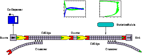
The main parts of a PLANSIM-T-network and how they are put together
Other Important
Classes")?>
After building the network, vehicles should drive on the EDGES. A class named CAR with several subclasses to accommodate the different car following models is in charge of this.
In addition, there are STATISTICMODULES. For the user they provide for example EDGE-data like average density, velocity and flow at a special point of time.
The Basic
Ideas")?>
Basically, PLANSIM-T works like this: The CARS drive on EDGES, which are connected to each other by CONNECTIONS. CARS that leave one EDGE are handed to the CONNECTION that follows that EDGE and lane. The CONNECTION knows which EDGE the CAR should go and then hands it to that EDGE. In case that movement can be blocked by other CARS or TRAFFICLIGHTS, this is measured by INSTRUMENTS. They can tell the CONNECTIONS not to let CARS pass through.
CA-Rules
Implemented")?>
In the actual version of PLANSIM-T
three car following modells are implemented:
- The Nagel-Schreckenberg-Model with minor modifications
due to german traffic regulations, i.e. overtaking on the right side
is forbidden. Here we use the CAEDGES.
- The Continous Model uses the
CONTEDGES. Overtaking on the right is
also forbidden here. This model is the continous limes of the
Nagel-Schreckenberg-Model.
- The Continuous Model with finite braking is based on the
idea that real cars have only finite braking abilities, e.g. it is not
possible to brake down from vmax to v =
0 in only one time-step. For every car the safe
velocity vSafe is calculated out of the distance to the car
ahead and it's velocity. The EDGES used here are called
SKEDGES.
Applications")?>
Here we present some applications:
- The following figure shows the fundamental diagram of a two lane
roundabout traffic with some thousand vehicles at different
densities. We used the CA with smooth braking. The
comparision of measured and simulated fundamental diagrams allow
quality estimations about the used car following models.
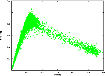
Fundamental diagram of an two-lane
roundabout traffic (smooth braking)
- In the next figure you see a more applicational simulation. On the
75000 km long german highway net there are more than one
million routed cars.
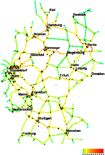
Simulation on the german highway net
- A more detailled network you see in the following figure. It shows
the road network of the northrheinwestfalion city Wuppertal. Here we
analysed for example what happens to the traffic if the highway
A 46 is completely closed.
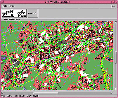
A simulation on the road network of Wuppertal
More traffic")?> For detailled information about our traffic simulation please click:
Motivation, Researchpartners.
Projects.
Used models.
Software.
Literature and Links.
Contact:
")?>
traffic@zpr.uni-koeln.de